landslide


A landslide near Cusco, Peru in 2018.

A NASA model has been developed to look at how potential landslide activity is changing around the world.
Contents
Causes

The Mameyes Landslide, in the Mameyes neighborhood of barrio Portugués Urbano in Ponce, Puerto Rico, which buried more than 100 homes, was caused by extensive accumulation of rains and, according to some sources, lightning.
- saturation by rain water infiltration, snow melting, or glaciers melting;
- rising of groundwater or increase of pore water pressure (e.g. due to aquifer recharge in rainy seasons, or by rain water infiltration);[2]
- increase of hydrostatic pressure in cracks and fractures;[2][3]
- loss or absence of vertical vegetative structure, soil nutrients, and soil structure (e.g. after a wildfire – a fire in forests lasting for 3–4 days);
- erosion of the toe of a slope by rivers or ocean waves;
- physical and chemical weathering (e.g. by repeated freezing and thawing, heating and cooling, salt leaking in the groundwater or mineral dissolution);[4][5]
- ground shaking caused by earthquakes, which can destabilize the slope directly (e.g. by inducing soil liquefaction), or weaken the material and cause cracks that will eventually produce a landslide;[3][6][7]
- volcanic eruptions;
- deforestation, cultivation and construction;
- vibrations from machinery or traffic;
- blasting and mining;[8]
- earthwork (e.g. by altering the shape of a slope, or imposing new loads);
- in shallow soils, the removal of deep-rooted vegetation that binds colluvium to bedrock;
- agricultural or forestry activities (logging), and urbanization, which change the amount of water infiltrating the soil.
_1950,_2.jpg)
The landslide at Surte in Sweden, 1950. It was a quick clay slide killing one person.
Types
 |
This article appears to contradict the article Landslide classification. (May 2014) (Learn how and when to remove this template message)
|
Debris flow
Slope material that becomes saturated with water may develop into a debris flow or mud flow. The resulting slurry of rock and mud may pick up trees, houses and cars, thus blocking bridges and tributaries causing flooding along its path.Debris flow is often mistaken for flash flood, but they are entirely different processes.
Muddy-debris flows in alpine areas cause severe damage to structures and infrastructure and often claim human lives. Muddy-debris flows can start as a result of slope-related factors and shallow landslides can dam stream beds, resulting in temporary water blockage. As the impoundments fail, a "domino effect" may be created, with a remarkable growth in the volume of the flowing mass, which takes up the debris in the stream channel. The solid–liquid mixture can reach densities of up to 2,000 kg/m3 (120 lb/cu ft) and velocities of up to 14 m/s (46 ft/s) (;[9][10]). These processes normally cause the first severe road interruptions, due not only to deposits accumulated on the road (from several cubic metres to hundreds of cubic metres), but in some cases to the complete removal of bridges or roadways or railways crossing the stream channel. Damage usually derives from a common underestimation of mud-debris flows: in the alpine valleys, for example, bridges are frequently destroyed by the impact force of the flow because their span is usually calculated only for a water discharge. For a small basin in the Italian Alps (area 1.76 km2 (0.68 sq mi)) affected by a debris flow,[9] estimated a peak discharge of 750 m3/s (26,000 cu ft/s) for a section located in the middle stretch of the main channel. At the same cross section, the maximum foreseeable water discharge (by HEC-1), was 19 m3/s (670 cu ft/s), a value about 40 times lower than that calculated for the debris flow that occurred.
Earthflow


A rock slide in Guerrero, Mexico
These flows usually begin when the pore pressures in a fine-grained mass increase until enough of the weight of the material is supported by pore water to significantly decrease the internal shearing strength of the material. This thereby creates a bulging lobe which advances with a slow, rolling motion. As these lobes spread out, drainage of the mass increases and the margins dry out, thereby lowering the overall velocity of the flow. This process causes the flow to thicken. The bulbous variety of earthflows are not that spectacular, but they are much more common than their rapid counterparts. They develop a sag at their heads and are usually derived from the slumping at the source.
Earthflows occur much more during periods of high precipitation, which saturates the ground and adds water to the slope content. Fissures develop during the movement of clay-like material which creates the intrusion of water into the earthflows. Water then increases the pore-water pressure and reduces the shearing strength of the material.[12]
Debris slide

Goodell Creek Debris Avalanche, Washington, USA
Steep coastal cliffs can be caused by catastrophic debris avalanches. These have been common on the submerged flanks of ocean island volcanos such as the Hawaiian Islands and the Cape Verde Islands.[13] Another slip of this type was Storegga landslide.
Debris slides generally start with big rocks that start at the top of the slide and begin to break apart as they slide towards the bottom. This is much slower than a debris avalanche. Debris avalanches are very fast and the entire mass seems to liquefy as it slides down the slope. This is caused by a combination of saturated material, and steep slopes. As the debris moves down the slope it generally follows stream channels leaving a v-shaped scar as it moves down the hill. This differs from the more U-shaped scar of a slump. Debris avalanches can also travel well past the foot of the slope due to their tremendous speed.[14]

Blockade of Hunza river
Rock avalanche
A rock avalanche, sometimes referred to as sturzstrom, is a type of large and fast-moving landslide. It is rarer than other types of landslides and therefore poorly understood. It exhibits typically a long run-out, flowing very far over a low angle, flat, or even slightly uphill terrain. The mechanisms favoring the long runout can be different, but they typically result in the weakening of the sliding mass as the speed increases.[15][16][17]Shallow landslide

Hotel Panorama at Lake Garda. Part of a hill of Devonian shale
was removed to make the road, forming a dip-slope. The upper block
detached along a bedding plane and is sliding down the hill, forming a
jumbled pile of rock at the toe of the slide.
Shallow landslides can often happen in areas that have slopes with high permeable soils on top of low permeable bottom soils. The low permeable, bottom soils trap the water in the shallower, high permeable soils creating high water pressure in the top soils. As the top soils are filled with water and become heavy, slopes can become very unstable and slide over the low permeable bottom soils. Say there is a slope with silt and sand as its top soil and bedrock as its bottom soil. During an intense rainstorm, the bedrock will keep the rain trapped in the top soils of silt and sand. As the topsoil becomes saturated and heavy, it can start to slide over the bedrock and become a shallow landslide. R. H. Campbell did a study on shallow landslides on Santa Cruz Island, California. He notes that if permeability decreases with depth, a perched water table may develop in soils at intense precipitation. When pore water pressures are sufficient to reduce effective normal stress to a critical level, failure occurs.[18]
Deep-seated landslide

Deep-seated landslide on a mountain in Sehara, Kihō, Japan caused by torrential rain of Tropical Storm Talas

Causing tsunamis
Landslides that occur undersea, or have impact into water e.g. significant rockfall or volcanic collapse into the sea,[20] can generate tsunamis. Massive landslides can also generate megatsunamis, which are usually hundreds of meters high. In 1958, one such tsunami occurred in Lituya Bay in Alaska.[13][21]Related phenomena
- An avalanche, similar in mechanism to a landslide, involves a large amount of ice, snow and rock falling quickly down the side of a mountain.
- A pyroclastic flow is caused by a collapsing cloud of hot ash, gas and rocks from a volcanic explosion that moves rapidly down an erupting volcano.
Landslide prediction mapping
Landslide hazard analysis and mapping can provide useful information for catastrophic loss reduction, and assist in the development of guidelines for sustainable land-use planning. The analysis is used to identify the factors that are related to landslides, estimate the relative contribution of factors causing slope failures, establish a relation between the factors and landslides, and to predict the landslide hazard in the future based on such a relationship.[22] The factors that have been used for landslide hazard analysis can usually be grouped into geomorphology, geology, land use/land cover, and hydrogeology. Since many factors are considered for landslide hazard mapping, GIS is an appropriate tool because it has functions of collection, storage, manipulation, display, and analysis of large amounts of spatially referenced data which can be handled fast and effectively.[23] Cardenas reported evidence on the exhaustive use of GIS in conjunction of uncertainty modelling tools for landslide mapping.[24][25] Remote sensing techniques are also highly employed for landslide hazard assessment and analysis. Before and after aerial photographs and satellite imagery are used to gather landslide characteristics, like distribution and classification, and factors like slope, lithology, and land use/land cover to be used to help predict future events.[26] Before and after imagery also helps to reveal how the landscape changed after an event, what may have triggered the landslide, and shows the process of regeneration and recovery.[27]Using satellite imagery in combination with GIS and on-the-ground studies, it is possible to generate maps of likely occurrences of future landslides.[28] Such maps should show the locations of previous events as well as clearly indicate the probable locations of future events. In general, to predict landslides, one must assume that their occurrence is determined by certain geologic factors, and that future landslides will occur under the same conditions as past events.[29] Therefore, it is necessary to establish a relationship between the geomorphologic conditions in which the past events took place and the expected future conditions.[30]
Natural disasters are a dramatic example of people living in conflict with the environment. Early predictions and warnings are essential for the reduction of property damage and loss of life. Because landslides occur frequently and can represent some of the most destructive forces on earth, it is imperative to have a good understanding as to what causes them and how people can either help prevent them from occurring or simply avoid them when they do occur. Sustainable land management and development is also an essential key to reducing the negative impacts felt by landslides.

A
Wireline extensometer monitoring slope displacement and transmitting
data remotely via radio or Wi-Fi. In situ or strategically deployed
extensometers may be used to provide early warning of a potential
landslide.[31]
 Global landslide risks
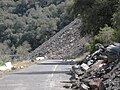 Ferguson Slide on California State Route 140 in June 2006
 Trackside rock slide detector on the UPRR Sierra grade near Colfax, CA


Prehistoric landslides

Rhine cutting through Flims Rockslide debris, Switzerland
- Storegga Slide, some 8,000 years ago off the western coast of Norway. Caused massive tsunamis in Doggerland and other countries connected to the North Sea. A total volume of 3,500 km3 (840 cu mi) debris was involved; comparable to a 34 m (112 ft) thick area the size of Iceland. The landslide is thought to be among the largest in history.
- Landslide which moved Heart Mountain to its current location, the largest continental landslide discovered so far. In the 48 million years since the slide occurred, erosion has removed most of the portion of the slide.
- Flims Rockslide, ca. 12 km3 (2.9 cu mi), Switzerland, some 10000 years ago in post-glacial Pleistocene/Holocene, the largest so far described in the alps and on dry land that can be easily identified in a modestly eroded state.[32]
- The landslide around 200 BC which formed Lake Waikaremoana on the North Island of New Zealand, where a large block of the Ngamoko Range slid and dammed a gorge of Waikaretaheke River, forming a natural reservoir up to 256 metres (840 ft) deep.
- Cheekye Fan, British Columbia, Canada, ca. 25 km2 (9.7 sq mi), Late Pleistocene in age.
- The Manang-Braga rock avalanche/debris flow may have formed Marsyangdi Valley in the Annapurna Region, Nepal, during an interstadial period belonging to the last glacial period.[33] Over 15 km3 of material are estimated to have been moved in the single event, making it one of the largest continental landslides.
- A massive slope failure 60 km north of Kathmandu Nepal, involving an estimated 10–15 km3.[34] Prior to this landslide the mountain may have been the world’s 15th mountain above 8000m.
Historical landslides
- The 1806 Goldau landslide on September 2, 1806
- The Cap Diamant Québec rockslide on September 19, 1889
- Frank Slide, Turtle Mountain, Alberta, Canada, on 29 April 1903
- Khait landslide, Khait, Tajikistan, Soviet Union, on July 10, 1949
- Monte Toc landslide (260 million cubic metres, 9.2 billion cubic feet) falling into the Vajont Dam basin in Italy, causing a megatsunami and about 2000 deaths, on October 9, 1963
- Hope Slide landslide (46 million cubic metres, 1.6 billion cubic feet) near Hope, British Columbia on January 9, 1965.[35]
- The 1966 Aberfan disaster
- Tuve landslide in Gothenburg, Sweden on November 30, 1977.
- The 1979 Abbotsford landslip, Dunedin, New Zealand on August 8, 1979.
- Val Pola landslide during Valtellina disaster (1987) Italy
- Thredbo landslide, Australia on 30 July 1997, destroyed hostel.
- Vargas mudslides, due to heavy rains in Vargas State, Venezuela, in December, 1999, causing tens of thousands of deaths.
- 2005 La Conchita landslide in Ventura, California causing 10 deaths.
- 2007 Chittagong mudslide, in Chittagong, Bangladesh, on June 11, 2007.
- 2008 Cairo landslide on September 6, 2008.
- The 2009 Peloritani Mountains disaster caused 37 deaths, on October 1.[36]
- The 2010 Uganda landslide caused over 100 deaths following heavy rain in Bududa region.
- Zhouqu county mudslide in Gansu, China on August 8, 2010.[37]
- Devil's Slide, an ongoing landslide in San Mateo County, California
- 2011 Rio de Janeiro landslide in Rio de Janeiro, Brazil on January 11, 2011, causing 610 deaths.[38]
- 2014 Pune landslide, in Pune, India.
- 2014 Oso mudslide, in Oso, Washington
- 2017 Bondo landslide, in Bondo, Switzerland
Extraterrestrial landslides

Before
and after radar images of a landslide on Venus. In the center of the
image on the right, the new landslide, a bright, flow-like area, can be
seen extending to the left of a bright fracture. 1990 image.

Landslide in progress on Mars, 2008-02-19
Landslide mitigation
 |
This article should include a summary of Landslide mitigation. See Wikipedia:Summary style for information on how to incorporate it into this article's main text. (July 2014)
|
Comments
Post a Comment